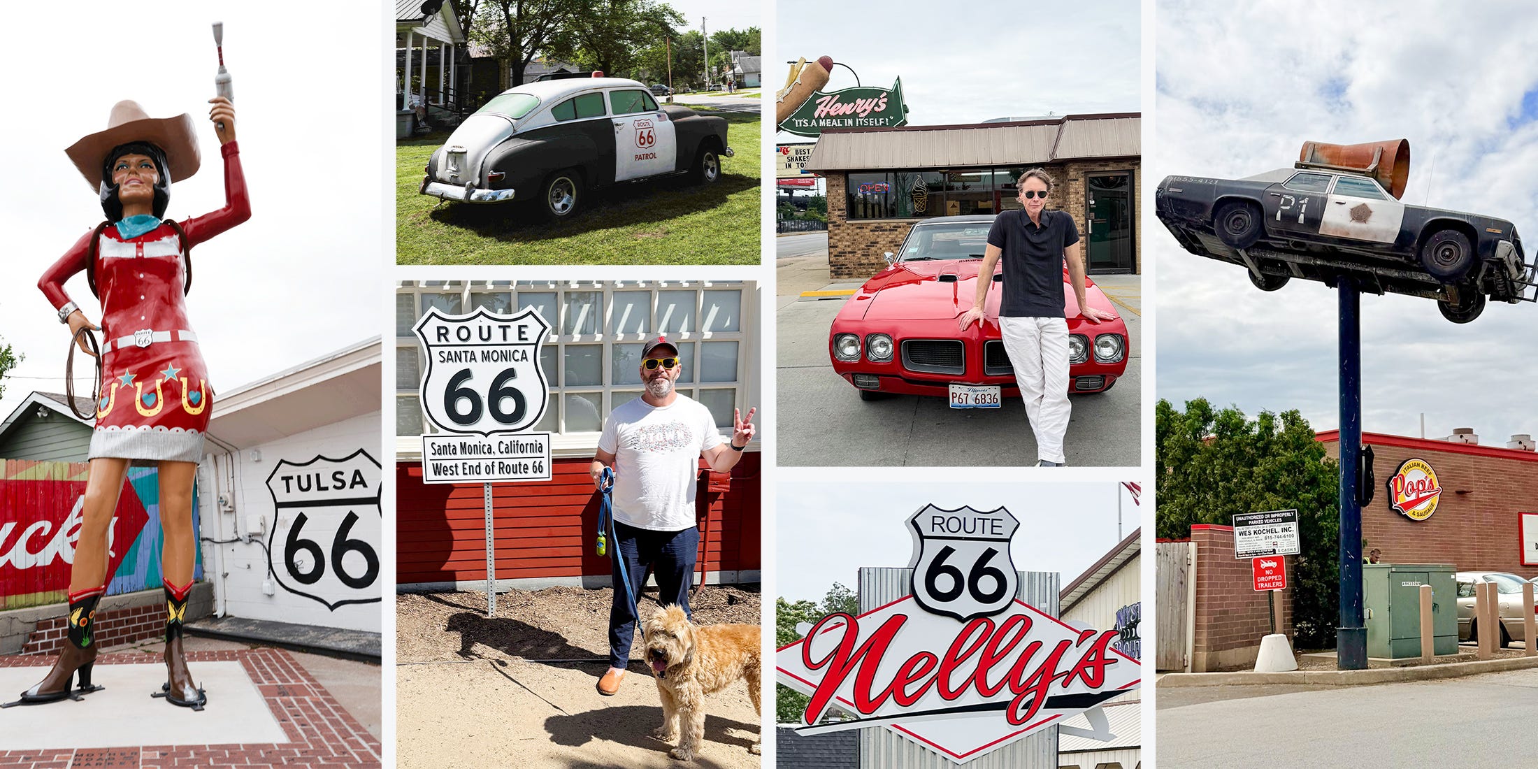
Route 66 at 100: The Enduring Highway Packed with Untold Stories That Could Change How You See America Forever
When you hear “Route 66,” what pops into your head? Classic cars cruising under neon lights? Big, bold roadside attractions screaming for your attention? Yeah, me too — but here’s the kicker: that snapshot barely scratches the surface. This legendary highway isn’t just a stretch of old pavement sprinkled with kitschy relics. Nope. It’s a living artery that once saved families, fueled small-town dreams, and connected a vast country in ways more profound than a simple road trip. Now, as it celebrates its centennial, Route 66 challenges us to look beyond nostalgia — to explore the grit, soul, and stories intertwined with every mile. So, buckle up. Let’s rediscover the Mother Road, not as a relic of a bygone era, but as a mirror reflecting America’s past, present, and the potential futures. Ready to hit the road? LEARN MORE
What most people think of when they think of Route 66 is old cars and kitsch. Perhaps that’s always how the past looks in the middle distance, when it’s too old to seem recent but too young to seem like capital-H History. But it’s uncharitable to America’s most well-known highway, whose pavement saved the lives of countless families, be they travelers or those small-town denizens whose fortunes were tied inextricably to the road, who ran service stations, diners, and shops. Those old cars were new once, and the kitsch, the stuff of real American lives.
The route turns 100 this year. The loping path from Chicago southwest to Santa Monica was designated 66 at the creation of the United States Numbered Highway System—not to be confused with Eisenhower’s later Interstate Highway System—in 1926. When the numbered highways were inaugurated, after more than a decade of Henry Ford’s moving assembly line, more than half of American families had a car but reliable, long-distance roads were scarce. The system emerged from the Good Roads Movement, an effort to develop roads that would put all those cars to what might be considered their highest and best—or perhaps most American—use: connecting urban to rural, customer to company, impoverishment to opportunity. And, as John Steinbeck famously wrote in The Grapes of Wrath, this was exactly how Route 66 was used:
66 is the path of a people in flight, refugees from dust and shrinking land, from the thunder of tractors and shrinking ownership, from the desert’s slow northward invasion, from the twisting winds that howl up out of Texas, from the floods that bring no richness to the land and steal what richness is there. From all of these the people are in flight, and they come into 66 from tributary side roads, from the wagon tracks and the rutted country roads. 66 is the mother road, the road of flight.
Nearly every one of us has at some point experienced a road trip as a kind of freedom. The freedom Route 66 granted was capital-H Historic.
We thought this year was a good time to explore Route 66 anew. Not only is it celebrating a birthday we all aspire to reach, but the sense of connection it fosters, in an age of loneliness, polarization, and economic uncertainty, is more important than ever. There’s also something deeper. Any road trip worth taking conjures something more, something like a sense of destiny. Nothing could be more appropriate right now, as our country celebrates its own monumental birthday.
We asked three parties to each take a different stretch of the route. Grant Achatz, the celebrated chef at Chicago’s Alinea, and his wife Sam Lim Achatz, the co-founder of Hi-Snaps, drove from the eastern terminus in downtown Chicago into rural Illinois. Ryan RedCorn, an Indigenous filmmaker, photographer, screenwriter, and graphic designer, explored a stretch of the highway that traverses tribal lands in Oklahoma. Esquire editor-at-large Dave Holmes took the last bit of the road before the country runs out of West. The diary each created from their travels captures old cars and kitsch, sure—but also a vision of America worth understanding, as well as glimpses of an America that could emerge from the Mother Road yet.
CHICAGO, IL
Running Away from the Clock

Route 66 starts five minutes from our house, right off Michigan Avenue in downtown Chicago. There’s a Route 66 sign there that’s almost completely covered in travel stickers left by visitors from around the world. But we had never driven it before. Honestly, we didn’t even know very much about it, other than what everyone knows—that it’s the Main Street of America, the Mother Road. So we hopped in Grant’s GTO to check it out.
There is something so romantic about the idea of a highway connecting all the main streets of all the small towns in the country. Especially for Grant, who grew up in a tiny town in Michigan, but has lived in Chicago for 30 years and not been home much.
Going from Chicago out into the more rural parts of Illinois, we felt like we were traveling through time. There were diners, old True Value hardware stores, even barber shops with the swirly poles. It was like an archive of America from 100 years ago; really, an emotional archive of America, that captures a time when the country had a very specific idea of itself.
We read up on the history of the route. One of the reasons the road was built was to drive revenue to small-town America. Drivers would pass through and spend their money. It showed off the country as it existed then, and helped the people out, too. Everything we now perceive as roadside kitsch, all the neon and the muffler men, were put there to draw traffic, literally. That’s not quite as romantic, but when you compare it to Instagram moments and discount codes and brand activations, we’ll take it. You, your car, and the road. It just seems so much more sincere and functional than the digital world we’re in now. It’s also a little lonely, maybe. That was our experience of Route 66: kind of weird, and lonely, and beautiful. —Grant Achatz and Sam Lim Achatz

We stopped for a hotdog pretty much right away. This place, Henry’s, is maybe two miles outside the Chicago city limits, in Cicero. We hadn’t even really left the urban sprawl yet, but we already felt like we were someplace else entirely. It was just so earnest. “It’s a meal in itself.” That’s kind of the diner experience.
Grant’s family had a diner his whole life, and his uncles and grandmother had diners, too, so we were not surprised by the feeling of community at Henry’s. We saw seven burly construction workers pull up in their pick-up trucks, come in for five-minutes to pick up their food, and then they were back to work. That’s the thing about a diner, and why it makes sense on Route 66—it’s homey, fast, convenient, and built around the American work schedule, qualities that can’t be any less important now than they were 50 or 100 years ago.

For all Grant’s experience growing up around diners, we still felt like we were clearly not regulars here. We ordered one hot dog, fries, and a milkshake to split between the two of us. Meanwhile, the woman behind us ordered four hot dogs, two fries, and a milkshake. (She claimed all that food was for her coworkers.) It was probably the best hot dog we’ve had in Chicago. They put the fries on the hotdog. Delicious.
This was also the first time on the trip that we had to remind ourselves that a place wasn’t retro as a conscious choice. Sure, they had picked their paint colors and decorated it to play up the Route 66 connection—but Henry’s opened in 1950. Its retro styling was authentic. Our first encounter with the time capsule nature of the road trip, which we loved.

We spotted this theater in Lockport, which is a good deal farther out of Chicago. Towns here are so small that you barely realize you’re driving into their Main Street before you’re on your way out again. This place became a theater in 1936. The neon was striking. Maybe it’s rose-colored nostalgia talking—it was probably just the most effective way to make a sign visible at night—but it reminded us of a time when people seemed to care as much about creating something memorable as they did about creating something efficient.

We go from mom and pop diners and charming movie theaters to… The Old Joliet Prison. The conditions there were brutal, the guys wore the black-and-white striped suits, they executed people. But in true American fashion, Old Joliet Prison may well have appeared in that theater we passed: It was used as a filming location in The Blues Brothers and on the TV show Prison Break.
The prison provoked completely different reactions in the two of us. Grant immediately started imagining what kind of pop-up dinner could happen there. Sam was convinced the place was haunted and wanted to leave. The prison closed in 2002 and is open now as—we hate to use this word—an attraction. It is for sure haunted. Our tour guide was a paramedic at the prison when it was still operating. He showed us pictures of literal ghosts. We honestly felt conflicted about going, but this was a real moment in American culture.

We asked two different people: We don’t have time to tour the entire prison. Where’s the best place we should go? They both said Death Row. This is Sam in the center of it, in the solitary confinement area. Each cell had a window, but it was 23 feet in the air. They got one piece of bread and one cup of water every 24 hours. That’s all. The electric chair was in the yard, right outside, so people would all see it. It wasn’t there anymore—another prison bought it. It was just a piece of equipment that was “useful” somewhere else. This was a different kind of time capsule. It was very physical. You could feel the weight of what happened there.

The prison actually had the best gift shop on the whole drive. It was nostalgic and sweet—very colorful, with Route 66 and Blues Brothers merch and a 25-year-old kid working the register. We saw Route 66 branded sodas everywhere we stopped, and the prison was no exception. After how dark and grim the prison was inside, this juxtaposition was surreal.

As we drove, we started to realize that all these roadside attractions felt fresh to us because they came from a completely different idea of what entertainment could be. There were no screens, no apps, no logins; just giant objects, neon signs, and roadside oddities designed to catch your eye and pull you in. A replica of the Bluesmobile from The Blues Brothers outside a travel center near Joliet shouldn’t have been as charming as it was. But that’s the thing about Route 66: What we expected to feel outdated often felt surprisingly alive. It made us realize how hungry we were for experiences that are tangible, specific, and rooted in the real world; things you can’t swipe past or experience through a screen.

It took us longer than expected to get a photo of a classic red barn. There was always a power line cutting across the frame, traffic driving through, or some other reminder that this wasn’t quite the postcard version of America. But barns were everywhere. Out here the landscape opens into vast stretches of farmland—mostly corn and soybeans, rather than the mix of crops that would have lined Route 66 in its early days. Still, the feeling remains: the Heartland of America begins surprisingly close to the city. What struck us most wasn’t the scenery itself, but the sense of pride and stewardship woven into it. Flags hung from barns and porches. Just look at this painted barn. All of a sudden there was this visceral, obvious, overwhelming pride for the country.

Wilmington is as far as we made it on this trip, and it ended up giving us our most memorable moment. The giant painted on the side of this building is the Gemini Giant, one of Route 66’s famous “muffler men,” oversized roadside figures built to catch the attention of passing drivers. The real Gemini Giant was just around the corner, so naturally we pulled over to see it. In the parking lot, Grant immediately spotted another muscle car, a ‘69 Cutlass convertible. Nearby, a man was sitting alone at a picnic table eating a sandwich. When we walked over to the Giant, he stood up and offered to take our photo. That simple gesture turned into a conversation.
He asked where we were coming from. We told him we were driving Route 66 from Chicago. He said he had moved to Wilmington a few years ago and now comes to this park almost every day because he always ends up meeting someone interesting. (He thought we were the weird ones to live life in the “big city.”) We realized we’d met more people on this one-day road trip than we do in weeks of normal life. Out here, people still seemed willing to stop, chat, and linger for a few extra minutes. And that was really nice. There is so much noise in modern life. Surely that man had his own noise, too. But sitting there in the park, he looked completely unhurried.
We left realizing that Route 66 isn’t really about giant statues or roadside attractions. It’s about making time and creating opportunities for unexpected encounters. And we hadn’t experienced that feeling in a very long time.
TULSA, OK
A Version of the Past—and Visions of the Future

Most people don’t know where Baxter Springs, Kansas is, let alone think of it as a “border town.” But there it sits, right on the border of Kansas and Oklahoma and a stone’s throw from Missouri. Oklahoma did not become a state until 1907; prior to that it was known as Oklahoma Territory; and prior to that it went by “Indian Territory.”
It’s easy to miss—these borders and boundaries. Every day we drive past signs, over bridges, all announcing themselves without consequence to our lives. Route 66 crosses many of these man-made and man-enforced edges. In Oklahoma, the route crosses nations—Tribal Nations. Most folks know Route 66 as a Main Street-to-Main Street affair, but in Oklahoma going from town to town means crossing multiple Tribal Nation jurisdictions in short order.
I’m a member of the Osage Nation (𐓷𐓘𐓻𐓘𐓻𐓟), a Dhegiha (𐓵𐓟𐓤𐓣𐓡𐓘) sister nation to one jurisdiction Route 66 (𐓪𐓻𐓘͘𐓤𐓟 𐓣𐓩𐓘) saunters through, the Quapaw Nation (𐓪𐓤𐓘𐓬𐓘). Going from Baxter into Oklahoma, I drove right into the Quapaw Nation. Border towns, or former border towns, often cropped up as close as possible to Indian (re)settlements as ideal trade locations. After the federal government crushed Indigenous subsistence economies, federal dollars flowed into those locations along with unscrupulous settlers who were given trade monopolies over tribes.
Remnants of this history are subtly visible if you look for clues left along Route 66. However, if you look only for the narratives of yesteryear, you will have hamstrung your trip. People drive Route 66 looking for a version of the past, but the future unfolding on the route is tethered to the uncelebrated, the unheralded, and the sidelined. —Ryan RedCorn (Osage/𐓷𐓘𐓻𐓘𐓻𐓟)

The Rainbow Bridge is a single-span concrete Marsh arch bridge built in 1923. It’s a joy to see a bridge like this standing. It is a reminder how, as a country, we once took the time to make things beautiful, even bridges. That matters because as bridge styles change, so does the mindset of people who cross them. The Rainbow Bridge boldly announces the passage over a waterway, Brush Creek. Modern bridges afford their patrons a level of dissociation from the land they are on and the water that flows through it. Today the Rainbow Bridge is somewhat decommissioned and most folks cross the modern bridge on the bigger road a few hundred feet away. Though, no one stops to photograph the modern bridge, myself included.

Nelson’s Old Riverton Store is a lovely family-owned shop just north of Baxter. When Americans think of midwestern Route 66 storefronts, this store is what appears in their minds. It feels like a movie set. It has a sandwich-serving deli in the back and everything from bug spray to fix-a-flat up front. On the rear of the property is a greenhouse, the bounty of which was being sold as curbside take-home flora. The sandwiches were delicious and the people were lovely. Unfortunately, despite driving nearly 120 miles of Route 66, this was the only store we encountered like this. Don’t call it a relic, though—it’s alive right now, and I’d gladly take one in my town.

We stopped here because the name on the front read Baxter’s Trading Post. Hoping to find some legit Indian trade goods we encountered something else entirely. Out back, the sign says “Baxter Family Snack Shack.” Here you will find a gigantic wood cutout of a gigantic clean-cut white man holding a gigantic hot dog in a giant bun as if it were a giant baby. Inside you will find Denise Wimmer, known on YouTube as The Dumpster Diving Granny, who is a lovely human, with a shop full of things that may or may not have been claimed prior to an unceremonious departure to a landfill. The shop includes a “game” section with various homemade arcade-style games, and a bar where you can get a short cold bottled water—fifty cents each—and, of course, hot dogs (regular sized).

Roadside historical markers are the captions of land. Whoever authors these has the unenviable task of trying to squeeze complicated histories into a few words (like this story) and then getting them through editors and committees, etc. This particular marker makes quick work of its topic. To paraphrase: There were some Indians here, they ceded the land, then more Indians were put here but then they got rich off minerals so it’s ok. The end. C’mon man. Were they charging y’all by the letter?
The truth is always more complicated. People died. Lots of people died. From colonization, and from the capitalism associated with mineral extraction. From Route 66, giant chat piles from the mines are clearly visible. Near this monument, the entire town of Pitcher was forcibly evacuated due to groundwater contamination, sinkholes, collapsing buildings from mine shafts, and neurological health effects from mine tailings. “Wealth came to the Quapaw and to other Indians,” the granite states. There’s a lot more space on that rock.

According to Quapaw oral history, the east and west legs of Route 66 finally met and were completed in Quapaw, Oklahoma. I’m not sure of the exact location of the completion, but it wouldn’t have been far from the Quapaw Farmer’s Market. When we pulled up, we were greeted by Quapaw tribal member Brittany Dixon. We pulled bison flank steaks from the freezer as Brittany chatted us up. The bison on the counter waiting to be rung up came from the Quapaw Nation’s herd and was processed at the Quapaw Nation’s slaughterhouse. When we told Brittany we were doing a little bit for Esquire, she suddenly became bashful. As I held up my camera, another Brittany came out of nowhere to show off her relative’s earrings. The Brittanies ran my card, laughed at us, and generously sent us on our way with some freezer packs. If you have never experienced the sweet music of two Native women cackling and laughing, you ain’t crossed enough borders.

This is the placeholder that lives rent free in the minds of most Americans. Nostalgia’s faithful representative, the roadside statue. Never mind the fact that this rendition closely resembles a Lakota, people who live far from Route 66, in the Dakotas. The American imagination loves the Indians of the movies and is not interested in parsing more than 500 distinct tribal Nations, let alone the 39 in Oklahoma. But this is way too harsh. The folks participating in this instantly recognizable art form want just one thing: They want you to stop and stay at their hotel, or restaurant, or curio, and spend your money. That’s it. And they all know this is the shit that makes someone pull their car over. It was as true when the artform emerged as it is true today. It even made me stop.

At first glance, Circle Cinema looks like just another Route 66 classic: beautiful old-school marquee, neon sign, lights, all the trappings. What is harder to see is the impact this little theater has had on the burgeoning Tulsa art scene. The sidewalk out front hosts Tulsa’s “STARS,” like the Hollywood Walk of Fame. These include Tim Blake Nelson, Jeannie Tripplehorn, and Sterlin Harjo, all of whom currently work on the TV series “The Lowdown,” which Harjo created and is filming right now in Tulsa. Over the decades, the theater hosted many of Harjo’s early feature films as well as films myself and other locals have made. Circle Cinema gave me my first solo photography exhibition. It’s a community arts cornerstone. The evening we were passing through coincided with the announcement of their Indian Territory film festival, whose roster included local Indigenous filmmakers and friends—people not content to let a roadside marker tell their stories or their histories.

The Arkansas River (𐓩𐓣𐓻𐓶𐓲𐓟) is a natural geographic border. It follows the contour of the land, a far cry from the engineered straight line of a road. As the river makes its way south into Oklahoma, it clips the southern edge of downtown Tulsa and goes under the Route 66 Arkansas River bridge. On the east bank there is a giant bronze statue entitled “East Meets West.” It depicts folks on a wagon whose horses are spooked by a Model T driven by Cyrus Avery, a Tulsa resident who is considered the “Father of Route 66.” Cyrus was part of the board establishing the Federal Highway System and personally championed the route.
The sculpture, in essence, implies we stand forever at the foot of progress, but someone is in the way. And since we are told how this story was ended, paved, written, and proclaimed, we are told folks need to get out of the way for progress to commence. But a few blocks from this statue is the location of the Tulsa Race Massacre, the burning down of Black Wall Street by a mob of deputized white folks. The statue, itself, sits in the shadow of Tulsa skyscrapers erected with the profits from oil pulled out from underneath Indian lands. Whole groups of people, deemed undeserving of their wealth, murdered, defrauded, and separated from “progress.”
Progress has to be better. I love a classic car. I love a beautifully illuminated and designed neon sign. I love eating food that is not poisoning me. I love a mom & pop shop and a local theater. I even love a good story. What I don’t love is redacted nostalgia, born from redacted history, memorialized and concretized by state-sponsored stories and monuments. History will happen, and it will continue to happen. It can be paved over, driven around, and outright ignored. But sooner or later, someone’s going to ask why the road ain’t straight. And there’s got to be a better answer than someone was in the way.
LOS ANGELES, CA
The End of the Road, or, the Promise of the West

Los Angeles is a city that beats you over the head with its kitschy landmarks (Look: it’s the Hollywood sign!) at the same time as it demolishes or repurposes them (Look: it’s the Brown Derby that’s now a Chase Bank!). Los Angeles holds onto its self-image as a place where people come to make their dreams of stardom come true, even as it increasingly becomes a place where people come to secure brand partnerships and podcast deals after their season of Love Island wraps. Tourists still come here, and when they ask me what they should see, I send them on the Warner Bros studio tour so they can see Central Perk and Stars Hollow.
Los Angeles is a figment of the American imagination, but in reality, it’s a vast, sprawling, often disconnected network of neighborhoods and cultures. The westernmost 20-ish miles of Route 66 take the motorist from Pasadena right through the center of Los Angeles city proper, all the way to the Santa Monica Pier over the Pacific Ocean. Driving it on a Sunday—as my partner Ben and I did with our dog Finbar recently, in a loaner Cadillac Blackwing, appropriately painted Dodger Blue—gives you a chance to see up close how those cities within the city shift and evolve. —Dave Holmes

We began our journey in the San Pascual neighborhood, an unincorporated “census-designated place” or “CDP” in Los Angeles County. I would tell you what that means, but it would distract from our objective here, and also I don’t know. What I can tell you for sure is that there’s an independent record store here called the Poo-Bah Record Shop, with an incredible selection of used R&B that we could have spent all day combing through, and that it looks like a half-dozen people were already doing just that.

Right next door, a bar called the Colorado Bar. When a bar has blacked-out windows, you know it’s for hardcore day drinkers. You know it’s going to be dank, in both the positive and negative definitions of that word. You know it’s going to be a Hold Steady song come to life. The Colorado Bar has no windows at all. Luckily it didn’t open until noon.

Route 66 is Colorado Blvd. in San Pascual and through Pasadena, where it’s the street with the Apple Store and the Ruth’s Chris Steak House. Right in the thick of downtown Pas, we witness the grand opening of the first U.S. location of a Korean beauty retailer called Olive Young. The line is down the block, and the slogan on the front window reads “The Beauty & Lifestyle Store for Everyday Young.” Given that we are Yesterday Young and there’s nothing to be done about that now, we drive on.
That takes us over one of Pasadena’s most beautiful landmarks, the Colorado Street Bridge. When you drive past the bridge on the 134, you can see its dramatic arches, Beaux-Arts railings, and gas lamps. When you drive on the bridge, you still know that those things are there, but they’re blocked by chain-link fences because the Colorado Street Bridge is also famous for being a thing people jump off of.

Once off the Bridge, as Pasadena turns into Eagle Rock, Route 66 becomes Figueroa Street. Within the rapidly-gentrifying Highland Park, near the Triple Beam Pizza and the Goldline—a hi-fi listening bar where nobody ever stops talking—we find “Chicken Boy,” a 22-foot statue that once stood atop a long-gone fried chicken restaurant. Arnold Schwarzenegger gave this statue the Historic Preservation Award when he was Governor, and the Los Angeles Explorers Club says many people call it “the Statue of Liberty of Los Angeles.” I doubt the veracity of this claim, but I am going to start saying it.

Chicken boys make us hungry, so it was time for lunch. A block or so off Route 66, on York Blvd. in Highland Park, is the Hermosillo, a spot with a killer smash burger, a solid selection of local craft beers, and a big outdoor space where kids and dogs are welcome, which means if you have been to one 40th birthday party in Los Angeles, it has almost definitely been here.

Figueroa St. merges into the 110 south out of Highland Park and past Dodger Stadium. There is a Dodgers home game about to start as we hit this part of the drive, so even though it’s a Sunday, we are treated to the quintessential Los Angeles experience: traffic. “This sucksty-sucks,” Ben says. Ben has never lied.
We get off at Sunset Blvd and take it through Echo Park and into Silverlake to Sunset Junction, where Route 66 becomes Santa Monica Blvd. This part of the drive is where your dreams of seeing a lot of auto body shops and Starbuckses comes true. Right near this intersection is Courage Bagels, where people stand in line in the baking sun to get a bagel they will take a picture of. Here we also see a Korean fried chicken restaurant, but there is no statue of a giant chicken-human hybrid, so who even knows what their deal is.

Like just about everyone we’ve met in Los Angeles, Ben and I are transplants: he from Greensboro, North Carolina, I from St. Louis. (Finny’s litter was born in Palm Desert, so he’s as close to a local as we have.) And though we’ve both been here for twenty-plus years, we both have trouble calling it “home.” It’s too big a place to get your arms around, if a friend moves eight miles away you are officially in a long-distance relationship, and there’s not even an LA Weekly to tell you who’s playing where anymore. It’s hard work to keep current with what’s happening around town.
This is my way of saying that it’s only as Route 66 takes us closer to West Hollywood, and the traffic gets slower and slower, that we learn that it is WeHo Pride Weekend, that the part of Route 66 that runs right through the few blocks of bars we call “Boystown” is the route of the Pride Parade, and that the parade is happening right now. I think we both thought maybe the other one would be keeping tabs on that kind of thing. But we didn’t, and we can’t get anywhere near it, so above is a photo of the event from Getty Images.

Route 66 goes above the office buildings and hotels of Century City, below the UCLA complexes of Westwood, and into Santa Monica. Once there, Route 66 makes one last left onto Lincoln and a right on Olympic, where it ends at a tiny street sign that says “END,” at a busy intersection where stopping to take a photo will get us killed. As I have with so many Hollywood productions, I have some notes on Route 66’s ending.
But there is a Route 66 Visitor’s Center right on the Santa Monica Beach Path, and it is closed. A bus shelter ad tells us that June 2026 is the 100-year anniversary of Route 66, and that a big celebration and parade is planned for the occasion. We look closer. It was three days ago.

Replacement for Samsung TV Remote, for All 2019-2026 Samsung Remote Control for Smart TV with Voice Control. 2-Year Warranty.
(as of July 14, 2026 02:54 GMT +00:00 - More infoProduct prices and availability are accurate as of the date/time indicated and are subject to change. Any price and availability information displayed on [relevant Amazon Site(s), as applicable] at the time of purchase will apply to the purchase of this product.)
Welch's Fruit Snacks, Mixed Fruit, Bulk Pack, Individual Single Serve Bags, 0.8 oz (Pack of 40)
(as of July 14, 2026 02:58 GMT +00:00 - More infoProduct prices and availability are accurate as of the date/time indicated and are subject to change. Any price and availability information displayed on [relevant Amazon Site(s), as applicable] at the time of purchase will apply to the purchase of this product.)
HONEY CARE All-Absorb A26 Male Dog Wrap, 50 Count, Small
(as of July 14, 2026 02:40 GMT +00:00 - More infoProduct prices and availability are accurate as of the date/time indicated and are subject to change. Any price and availability information displayed on [relevant Amazon Site(s), as applicable] at the time of purchase will apply to the purchase of this product.)
xinwld Adaptive Hybrid Active Noise Canceling 2026 Wireless Earbuds, 6 Mics ENC Clear Call Ear Buds, Hi-Res Audio Deep Bass Bluetooth 5.4 Headphones, 40H, LED, for Sports Running Gym Workout, Black
(as of July 14, 2026 03:00 GMT +00:00 - More infoProduct prices and availability are accurate as of the date/time indicated and are subject to change. Any price and availability information displayed on [relevant Amazon Site(s), as applicable] at the time of purchase will apply to the purchase of this product.)


Post Comment